Overview
The property descriptions reflect a boundary survey and must be signed and sealed by an RPLS. Property descriptions prepared for ROW projects consist of a heading with TxDOT identification items, along with a regular metes and bounds description and parcel plats prepared on letter size sheets numbered (1 of 4, etc) successively for unification. Letter size sheets allow the descriptions and plats to be filed with the County Clerk's office without reducing copies. Examples of
are available. Below is an example of a typical TxDOT heading.
NOTE: Use a one-inch border on all sides.
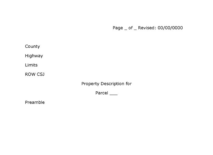
Figure 4-1.
Items to be included on property descriptions, in addition to TBPLS standards, include:
- All property descriptions must be tied to the Texas Coordinate System of 1983, and reference metadata (history data) used in preparing the survey.
- Parcel plats are included in all property descriptions as one document.
- For all partial acquisitions, at least one reference tie must be made to an established corner outside the parcel area. It is preferable to use a found back corner of the remainder. It is acceptable to use a set corner on the remainder or adjoiner in cases where no found corners exist, although the surveyor may be assuming liability for the remainder as well as for the adjoiner tract. This outside tie should be made to a monumented boundary corner that will remain after construction.
- If the parcel is located in more than one county or land grant survey, show the land area in each county or land grant areaas separate parcels.
- Access denial lines shown on the right of way/property line to designate the property interest being conveyed. See for a visual depiction.
Existing Information.
- existing ROW monuments;
- existing access control areas;
- record ownership data of adjacent properties;
- ROW PCs, PTs, and PIs (show and label);
- existing centerline information including incremental stationing, PC, PT and PI data;
- existing utility lines and easements (deed reference, if available);
- existing improvements such as buildings and fences, etc.;
- potential obstructions and/or encroachments. (Locate any improvements bisected by or within 50 feet of the new ROW line. This will assist appraisers in determining damages to the remainders of properties.)
- survey lines (show and label);
- city limit lines (show and label);
- county lines (show and label);
- existing public roads, streets and alleyways (include recorded plat or deed reference);
- existing drainage or channel easements (include recorded plat or deed reference);
- on a separate page of the parcel plat, show the whole property relative to existing and proposed ROW.
Proposed Information.
- new ROW lines;
- new ROW markers;
- proposed centerline information including incremental stationing, PC, PT and PI data;
- portions of the proposed design. Although a ROW map is not to be used to construct a highway, you should show, by a single line, the following proposed items or additional topography information:
- frontage roads;
- main lanes;
- connecting ramps.
When control of access is used, it should be described in a recorded deed, and shown on the parcel plat and described in the field note portions of the property descriptions. Limits of denied access should be staked on the ground, and shown or described in the property description using the terms 'Denial of Access’ or ‘Access Denial Line'. Access control descriptions must be signed and sealed by an RPLS.
Parcel Information.
- property owner name;
- parcel number;
- parent tract;
- surface coordinates of the point of beginning (POB);
- station to station limits and offset to project centerline;
- area in acres and/or square feet;
- area of remainder in relation to right and left of project centerline (calculated from deed reference only);
- property lines, (show and define by bearing and distance relative to existing and new ROW lines);
- a bearing and distance to a monumented controlling corner outside the area to be acquired. If the corner is defined as a point of commencement (POC) in a property description, show the letters P.O.C. on the map with reference of the parcel to which it is tied.
Parcels consisting of more than one part must include a summary at the end of the property description as follows:
Summary
Part 1 = 4.333 Acres (188745 ± square feet)
Part 2 = 2.667 Acres (116174 ± square feet)
Total = 7.000 Acres (304919 ± square feet)
Property descriptions covering more than one page should read "
Page___of____
." Include the parcel plats as part of the entire document. For example, when there are three pages of a property description and three pages of a parcel plat, identify each as being one of six pages, and read "Page __ of 6."At the end of each property description, add a sentence stating "This property description is accompanied by a separate plat." All property descriptions must be signed and sealed by an RPLS, and must include a statement that the survey was performed on the ground under his supervision and must include the day, month and year of the
survey.