36A
Houston
Introduction
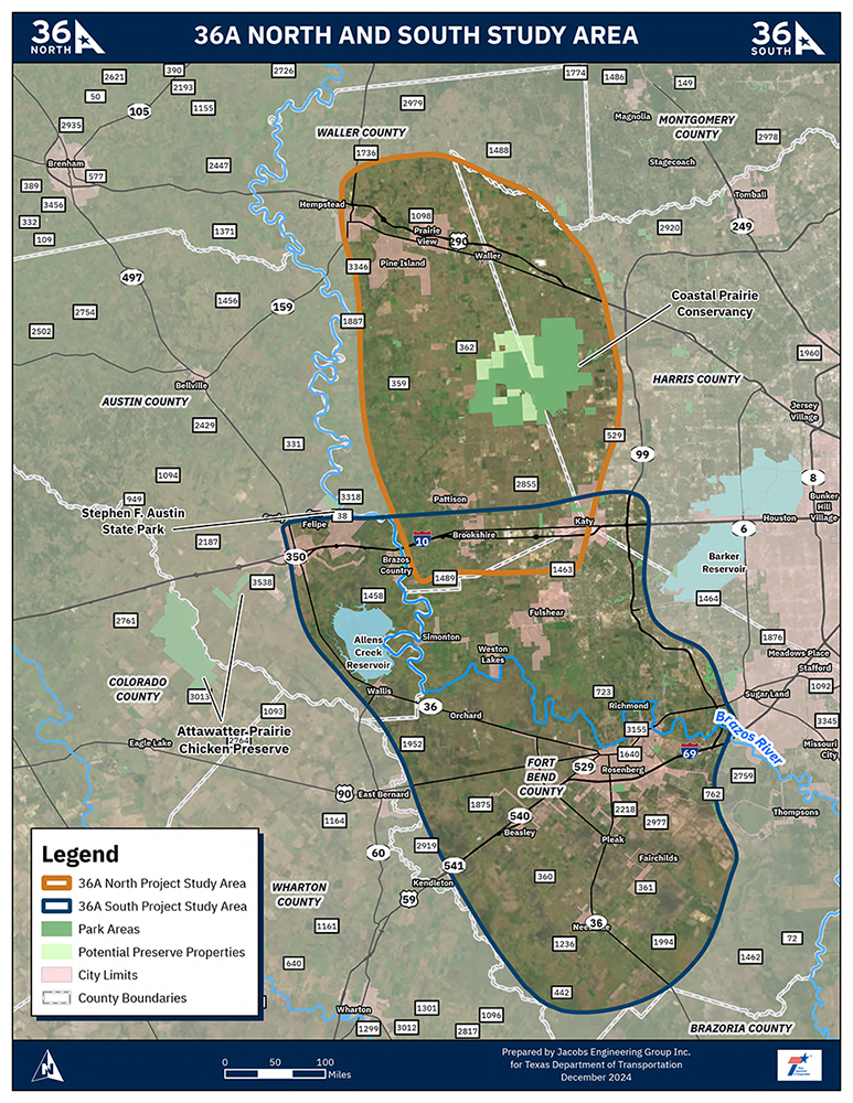
TxDOT Houston District proposes to construct a new transportation facility to serve areas west of the Houston Metropolitan Area. Due to the lack of adequate north/south transportation facilities west of the Houston core, the facility is being developed to provide more efficient north/south mobility between, in general, the Needville and Hempstead areas. A new facility would improve connectivity and mobility, add an additional transportation route for hurricane or other emergency evacuation needs, and help relieve congestion issues on existing roadways. The project is divided into two segments, north and south. An individual Environmental Impact Statement (EIS) is being developed for each segment. The proposed facility is anticipated to be, in total, approximately 65 to 75 miles in length and located in Fort Bend and Waller counties. The limits of each project are described as follows:
- 36A North would extend from I-10 to US 290/SH6
- 36A South would extend from FM 1994 south of Needville to I-10
Please subscribe to project updates and click on the links provided for additional information on each segment.


Study background
-
Since 2017, the study team has held informational meetings with elected officials, local stakeholders, public and private organizations, and major landowners to introduce the proposed project, provide an update on the project development status, and receive informal input. Originally the new facility was being developed as one project. However, through these meetings, Fort Bend and Waller County representatives requested the project to be split into two stand-alone projects, north and south, with the I-10 corridor dividing the two segments.
-
The Houston-Galveston Area Council’s 2023 Regional Goods Movement Plan is a Long-Range Plan for the movement of goods within the region. Part of that plan includes the Urban Core Relief Route concept to remove freight traffic from the urban core of the Houston Metropolitan area. This concept includes a proposed north-south roadway along the western edge of the Houston Region connecting Interstate (I)-69/US Highway (US) 59 west of Rosenberg in Fort Bend County to I-10 and US 290/State Highway (SH) 6 in northern Waller County. From a regional perspective, this western route originates from the existing SH 36 corridor and diverges away from existing SH 36 toward the north, hence the name 36 Alternate, or 36A.

Environmental studies
In Texas, all roadway projects located on a State facility or receiving Federal or State funds are required to go through a detailed environmental analysis process. The 36A North and South projects are anticipated to receive federal funding, so they are required to follow the National Environmental Policy Act (NEPA) process. NEPA requires agencies to consider environmental and related social and economic effects of their proposed actions. Among the many requirements, the NEPA process includes public engagement and preparing draft and final EISs to inform decision makers and the public about the environmental effects of an agency's actions. An EIS also helps agencies consider alternative actions that could minimize adverse impacts.
TxDOT is preparing two separate EISs, one for 36A North, and the other for 36A South. Each EIS will evaluate impacts to the human and natural environment, including but not limited to, traffic noise, the community, natural resources, cultural resources, and hazardous material sites.