Project timelines
Construction timeline & phasing
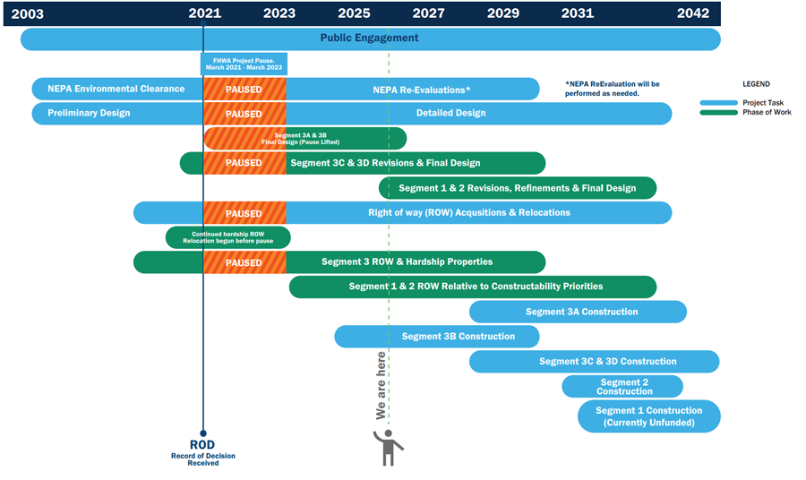
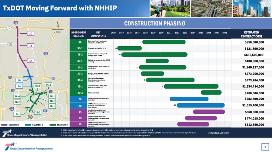
All estimated dates shown are preliminary and subject to change.
In order to ensure that pedestrian and bike access to schools is maintained during construction, TxDOT will develop plans during the detailed design phase for traffic control detours of pedestrian and cyclist movements showing the locations of schools adjacent to the project footprint, existing routes traveled by children to these schools, routes during construction, and the anticipated finished condition of pedestrian and cyclist routes after construction on the project is completed.
Where construction of the project will require pedestrian and bicycle detour routes to maintain access to schools, TxDOT commits to bring such designated detour routes up to current standards prior to beginning the associated construction in order to ensure that students, staff, and the public continue to have safe and accessible pedestrian and bicycle paths of travel to project adjacent schools.
TxDOT will design and direct its contractor to maintain non-circuitous sidewalks to maintain safe pedestrian and cyclist access to schools during and after construction.
TxDOT will work directly with schools to develop parent and school bus drop-off and pick-up routes, direct TxDOT contractors to maintain the safe operations of these routes during construction, and inform decisions about appropriate detour routes with the goal of safety and minimizing increased commute times.
TxDOT will maintain communication with school officials for the design of access accommodations during the construction phase.
TxDOT will provide an ombudsman for the schools to communicate concerns that arise during construction to TxDOT in order for timely resolution of concerns.
Once construction starts, this website will be updated to inform the public about bicycle and pedestrian access including maps.
Where construction of the project will require pedestrian and bicycle detour routes to maintain access to schools, TxDOT commits to bringing such designated detour routes up to current standards prior to beginning the associated construction in order to ensure that students, staff, and the public continue to have safe and accessible pedestrian and bicycle paths of travel to project adjacent schools.
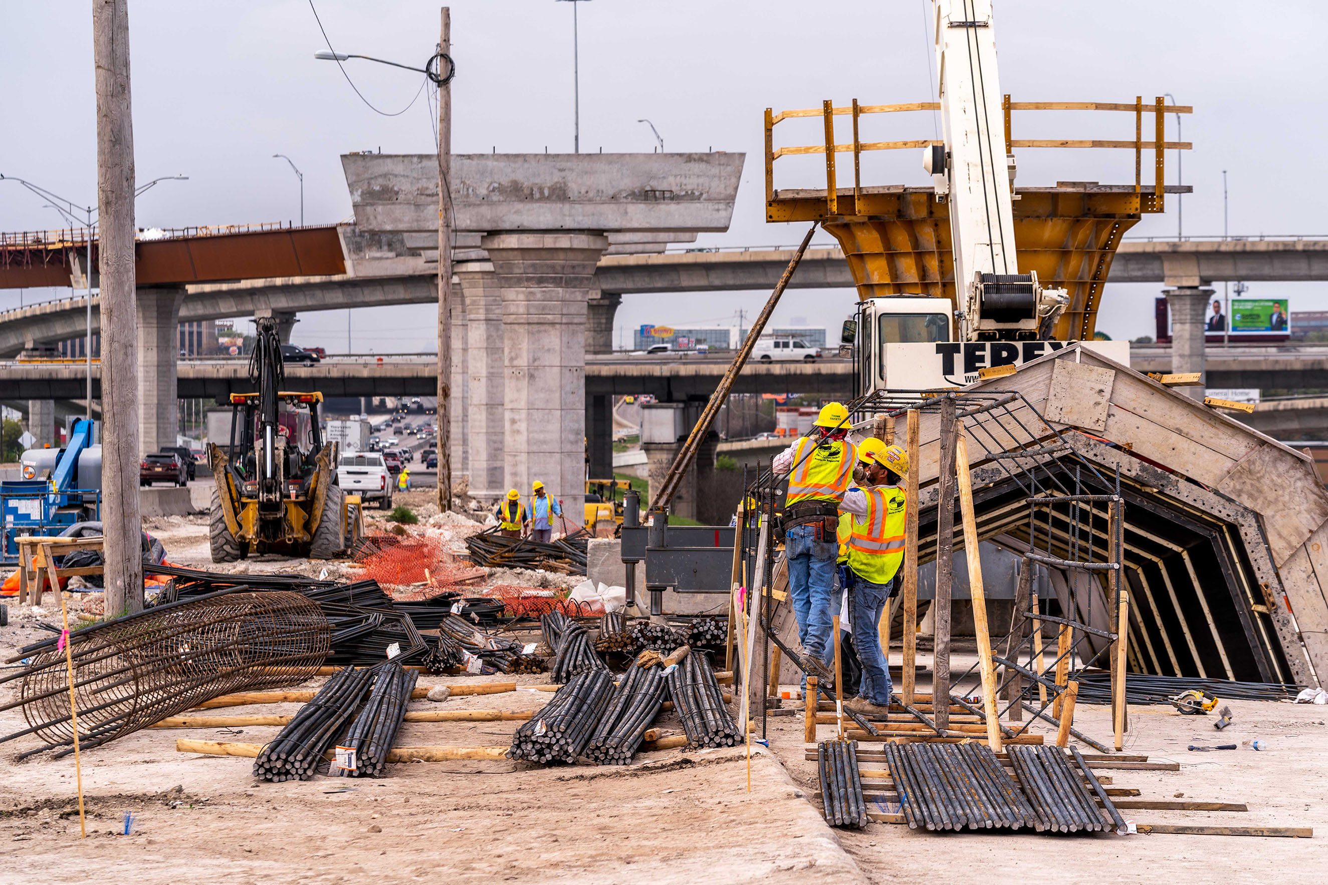
Construction is anticipated to begin in 2024 along St. Emanuel between IH 45 South and Buffalo Bayou to install drainage improvements for a portion of the NHHIP. Please report concerns about construction activities by emailing us at hou-piowebmail@txdot.gov, calling us at 713-802-5076 or visiting us at 7600 Washington Ave. Houston, TX 77007.
TxDOT will obtain METRO's review and comment of the construction work phasing and sequencing of light rail facilities and operations that are impacted by construction.
TxDOT will obtain METRO's review and comment in instances where a bus stop needs to be temporarily relocated during construction.
TxDOT will provide fourteen (14) calendar-day public notices of bus and light rail service disruptions due to construction activities.
TxDOT will post notices of bus and light rail service disruptions on this website and will coordinate with METRO for notices to be posted on METRO's website.
This website will be updated to provide notices of disruption from construction work including bus reroutes, road closures and detours, trail closures, demolitions, and late-night activity.
Please use the following link to subscribe to receive construction alerts.
Project history
- Memorandums of Understanding (MOU) reached with City of Houston and Harris County
- Federal Highway Administration (FHWA) places I-45 NHHIP on pause
- Issues Record of Decision
- 2020 Interstate Access Justification Report-Segments 2 and 3
Updated recommended Alternative Design Schematics- December 2019
Based on comments received during the draft EIS comment period and from continuing stakeholder input and coordination, TxDOT has revised the Proposed Recommended Alternative that was presented at the May 2017 public hearing. The revised alternatives for each project segment will be identified as the Preferred Alternatives in the final EIS, and will be the Preferred Alternative for the proposed North Houston Highway Improvement Project (NHHIP).
The updated design schematics can be viewed at the links below.
Segment 1- December 2019:
- Segment 1: I-610 to Tidwell Road
- Segment 1: Tidwell Road to Shepherd Drive
- Segment 1: Shepherd Drive to West Road
- Segment 1: West Road to Beltway 8
Segment 2- May 2019:
Segment 3- May 2019:
- Segment 3: Downtown Loop Overall Plan View
- Segment 3: I-45 from Scott St. to I-69
- Segment 3: I-45 from I-69 to Elysian St.
- Segment 3: I-45 from Elysian St. to Wrightwood St.
- Segment 3: I-69 from Montrose Blvd. to I-45
- Segment 3: I-69 from I-45 to Lyons Ave.
- Segment 3: I-10 from Houston Ave. to McKee St.
- Segment 3: I-10 from McKee St. to Waco St.
- Segment 3: SH 288 from Binz St./Calumet St. to I-45
- Segment 3: Downtown Connectors
- 2018 NHHIP Alternatives Analysis: Engineering and Traffic Criteria Report
- 2018 TxDOT list of top 100 congested roadways in Texas developed by the Texas A&M Transportation Institute (TTI)
- 2018 American Transportation Research Institute’s top truck bottleneck list
- Review and prepare responses to draft EIS comments
- Publish draft technical reports on project website for public comment (2018 - 2020)
- Prepare final technical reports
- Prepare final Environmental Impact Statement (final EIS)
- Complete draft Environmental Impact Statement (draft EIS)
- Request public input on draft EIS and circulate for comment
- Public hearing- May 9 and 11, 2017
- Community meeting- May 15, 2017
- Request public and agency input on Proposed Recommended Alternative
- Fourth cooperating and participating agency meetings: April 22, 2015
- Fourth public meeting: April 23, 28, and 30, 2015
Fourth scoping meeting documents:
- NHHIP Agency Coordination and Public Involvement Plan
- Cover and table of contents
- Project background
- Section 1: Summary of agency and public meetings
- Section 2: Public meeting comments and responses
- Appendix A: Mailouts
- Appendix B: Sign-in sheets
- Appendix C: Meeting notices
- Appendix D: Other media
- Appendix E: Meeting photographs
- Appendix F: Meeting handouts and comment form, presentation, and TxDOT booklets
- Appendix G: Meeting exhibits
- Appendix H: Comments
Fourth public meeting documents- April 2015:
- Fourth public meeting notice
- Aviso de cuarta reunión pública
- Map of public meeting locations
- Handout for cuarta public meeting
- Repartir de cuarta reunión pública
- Presentation for fourth public meeting
- Presentacion de cuarta reunión pública
- Exhibit boards for fourth public meeting
- Glossary of terms
Proposed Recommended Alternative Conceptual Roadway Layouts and Typical Sections- April 2015:
- Segment 1: I-610 to Tidwell Road
- Segment 1: Tidwell Road to Shepherd Drive
- Segment 1: Shepherd Drive to West Road
- Segment 1: West Road to Beltway 8
- Segment 2: I-610 Interchange
- Segment 2: North of I-10 to I-610
- Segment 3: South of Downtown Houston to I-10
- Segment 3: Eastern Area
- Segment 3: Western Area
- 3D Visualization Video View transcript
- Project briefing packet (April 2015)
- 2014 I-45/Hardy Corridor Study Update, which utilized the 2015 and 2035 H-GAC travel demand models
- Refine Alternatives to one proposed Recommended Alternative
- Request public and agency input on Reasonable Alternatives
- Third cooperating and participating agency meetings: Nov. 13, 2013 and Nov. 14, 2013
- Third public meeting: Nov. 14 & 19, 2013
- First phase of North Corridor Light Rail Transit (LRT) opens: December 2013
Third scoping meeting documents:
- Vol. 1 Cover & table of contents
- Vol. 1 Section 1 Summary and photographs
- Vol. 1 Section 2 Meeting notification
- Vol. 1 Section 3 Registration
- Vol. 1 Section 4 Handouts
- Vol. 1 Section 5 Presentation
- Vol. 1 Section 6 Exhibit boards
- Vol. 2 Cover and Table of contents
- Vol. 2 Section 1 Introduction and comment index
- Vol. 2 Section 2 Email comments
- Vol. 2 Section 3 Mail comments
- Vol. 2 Section 4 Form letters
- Vol. 2 Section 5 Website comments
- Vol. 2 Section 6 Written comments submitted at scoping meetings
- Vol. 2 Section 7 Surveys
- Responses to comments
Third public meeting documents:
- Third public scoping meeting notice
- Aviso de tercera reunión pública
- Handout for third public meeting
- Repartir de tercera reunión pública
- Third public meeting: presentation with notes
- Presentacion de tercera reunión pública con notas
- Exhibit boards for third public scoping meeting
- Tablero de exhibiciones para reunión de tercera alcance público
- Third public meeting: glossary of terms
- Right-of-Way: Segment 1 - I-610 to Tidwell
- Right-of-Way: Segment 1 - Tidwell to gulf Bank section
- Right-of-Way: Segment 1 - Gulf Bank to Northville section
- Right-of-Way: Segment 1 – Northville to BW8
- Right-of-Way: Segment 2 – Alternatives
- Right-of-Way: Segment 2 – Alternatives 45 to I610
- Right-of-Way: Segment 2 – Alternatives I10 to I610
- Right-of-Way: Segment 3 – Alternative 10
- Right-of-Way: Segment 3 – Alternative 11
- Right-of-Way: Segment 3 – Alternative 12
- Reasonable Alternatives: Segment 1 3D
- Reasonable Alternatives: Segment 2 3D
- Reasonable Alternatives: Segment 3 3D
- Develop Range of Project Alternatives
- Develop Alternative Evaluation Methodology to assess impacts
- Request public and agency input on Range of Alternatives and present approved Need and Purpose Statement and Agency Coordination and Public Involvement Plan
- Second cooperating and participating agency scoping meetings: Oct. 10, 2012
- Second public scoping meeting: Oct. 9 & 11, 2012
- Analyze Range of Alternatives to determine Preliminary Alternatives to be studied in detail
Second scoping meeting documents:
- Vol. 1 Cover & table of contents
- Vol. 1 Section 1 Summary and photographs
- Vol. 1 Section 2 Meeting notification
- Vol. 1 Section 3 Registration
- Vol. 1 Section 4 Handouts
- Vol. 1 Section 5 Presentation
- Vol. 1 Section 6 Exhibit boards
- Vol. 2 Cover and table of contents
- Vol. 2 Section 1 Introduction and comment index
- Vol. 2 Section 2 Email comments
- Vol. 2 Section 3 Mail comments
- Vol. 2 Section 4 Form letters
- Vol. 2 Section 5 Website comments
- Vol. 2 Section 6 Written comments submitted at scoping meetings
- Vol. 2 Section 7 Surveys
- Responses to comments
Second scoping meeting documents:
- Second public meeting notice
- Aviso de segundo reunión de alcance público
- Handout for second public scoping meeting - October 2012
- Repartir de segundo reunión pública- Octubre 2012
- Presentation from second public scoping meeting - October 2012
- Exhibit boards for second public scoping meeting - October 2012
- Glossary of terms for second public scoping meeting - October 2012
- Universe of Alternatives summary table
- Universe of Alternatives Segment 1
- Universe of Alternatives Segment 1 - I-45 aerial map
- Universe of Alternatives Segment 1 - Hardy and Beltway 8 aerial map
- Universe of Alternatives Segment 2
- Universe of Alternatives Segment 3
- Universe of Alternatives Segments 2 and 3 - aerial map 1
- Universe of Alternatives Segments 2 and 3 - aerial map 2
- Publish the Notice of Intent to prepare an Environmental Impact Statement (EIS) – Federal Register, Oct. 24, 2011; Texas Register, Oct. 14, 2011
- Develop draft Need and Purpose Statement and draft Agency Coordination and Public Involvement Plan
- Request Public and Agency Input on draft Need and Purpose Statement and draft Agency Coordination and Public Involvement Plan
- First cooperating and participating agency scoping meetings: Nov. 14, 2011
- First public scoping meeting: Nov. 15 and 17, 2011
First scoping meeting documents:
- Vol. 1 Cover & table of contents
- Vol. 1 Section 1 Summary and photographs
- Vol. 1 Section 2 Meeting notification
- Vol. 1 Section 3 Registration
- Vol. 1 Section 4 Handouts
- Vol. 1 Section 5 Presentation
- Vol. 1 Section 6 Exhibit boards
- Vol. 2 Cover TOC & Section 1 introduction and comment Index
- Vol. 2 Section 2 Email comments
- Vol. 2 Section 3 Mail comments
- Vol. 2 Section 4 Website comments
- Vol. 2 Section 5 Written comments submitted at scoping meeting
- Vol. 2 Section 6 Surveys
- Vol. 2 Section 7 Verbal comments at scoping meeting
- Responses to comments
- 2005 North-Hardy Planning Studies – Alternatives Analysis Report - Highway Component
- Publish final report: North-Hardy Planning, Alternatives Analysis Report - Highway Component
- North-Hardy Alternatives Analysis Report - Transit component is completed: February 2004
- Review long list of highway alternatives: June 2004
- Draft recommendation of Highway Alternative presented publicly. Public feedback modified the draft Highway Alternative: Oct. 26 & 28, 2004
- 2004 North-Hardy Planning Studies – Alternatives Analysis Report (Transit Component)
- Community requests that the Highway Component of the North-Hardy Corridor Alternatives Analysis Report be set aside until the transit component is completed
- Initiate North-Hardy Corridor Alternatives Analysis Report-Transit Component: July 28, 2003
- Locally Preferred Transit Investment Strategy is approved by METRO Board and the voters: November 2003
- Notice of Intent from FHWA, TxDOT, METRO & H-GAC partner to conduct North-Hardy Planning Studies and Environmental Impact Statement: January 9, 2002
- Technical work sessions with consultant, METRO, TxDOT and H-GAC: May 6, 2002
- Public review process with stakeholders from six North-Hardy segments and three general public meetings, culminating with the Stakeholder Advisory Committee.


